Sunday, December 1, 2024

Celebrating Retirement

On the first day of my retirement, I left town and travelled to Skagway, Alaska.  This was not a convenient place to reach.  I left Boston at 6:00am on Saturday, October 19, 2024, on Air Canada, changed aircraft in Toronto and Vancouver, and flew into Whitehorse, the capital of the Yukon Territory.  Following a roller coaster flight through wild turbulence over the Rocky Mountains, the diminutive airplane touched down in a snow-saturated landscape at 5:00pm.  My son James met me at the Whitehorse airfield.  After dinner in a local restaurant, we made the two-hour drive through the mountains of the Yukon, northwestern British Columbia, and southeastern Alaska to Skagway and sea level.  My objective in travelling to this remote location was to spend several days visiting James and seeing his excursion trains and cruise ships.

Skagway sits at the head of navigation on the Lynn Canal.  Not really a canal at all, this body of water is one of the many fjords and bays that comprise the Inside Passage, a network of inland waterways that stretches from Washington through British Columbia to Alaska and is sheltered from the open Pacific by a series of islands and peninsulas.  Long an important route for commercial shipping, the Inside Passage is now frequented largely by cruise ships and ferries.  Many of these stop at Skagway, the place where the shipping lines and the railroad meet.

James’ employer, the White Pass and Yukon Route, operates excursion trains for the cruise ship passengers.  These trains embark everyone at the docks downtown and then run “up the hill” on a line that climbs mountains, skirts river gorges, ducks through tunnels, crosses bridges, and delivers the sightseers to scenic spots in British Columbia and the Yukon.  The entire route is tremendously scenic, and therein lies the appeal to folks on vacation.  After several hours of sightseeing aboard the trains, the railroad returns the passengers to the docks in Skagway, and there they rejoin their cruise ships and put to sea again.

As a guest of the White Pass, I had the privilege of riding these trains and sitting up front in the locomotive with James at the controls.  This made for a fascinating series of journeys up the hill and back down again, and to both the cruise ship piers downtown and the railroad shops at the edge of town.  It was late in the tourist season, however, and instead of lush foliage in the mountains, there lay a thick carpet of snow with walls of icicles clinging to the rocks.  It was a very impressive and truly beautiful landscape; nonetheless, I still felt drawn to the waterfront, and I found it just as appealing.

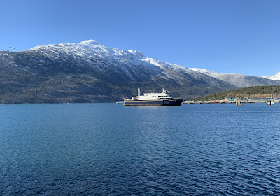
The mountains and the sea together formed my favorite part of the landscape.  Two worlds met at the Skagway waterfront; it was a confluence of geology and oceanography and a place of breathtaking beauty.  Little wonder that so many people sailed there to see it.  My first view of this waterfront took place on Sunday afternoon, October 20.  Watching from an empty cruise ship pier, James and I witnessed the arrival of the ferry Hubbard of the Alaska Marine Highway from Juneau.  I took a sequence of photographs of this event, and I’m happy to present the best ones here:


There were no cruise ships in port that day, nor on the Monday following, but the Norwegian Bliss of the Norwegian Cruise Line arrived on Tuesday the 22nd, and I was able to take one good picture of her.  The weather had changed by this time.  It was snowing along the railroad in the mountains, but raining at sea level, and so here we see the Norwegian Bliss through the rain:

The next day, Wednesday the 23rd, saw the arrival of the Norwegian Jewel, also of the Norwegian Cruise Line.  The rain and snow had stopped by this time, but a strong and bitterly cold wind was blowing instead, and this made photography challenging.   Nonetheless, I was able to capture a few views of the Norwegian Jewel at her berth:


In this last photograph of the port side amidships, we see how modern cruise ships can resemble high-rise apartment buildings ashore instead of traditional transoceanic passenger liners.  A bold new concept in sea travel, cruising has proven tremendously popular with vacationers.

Wednesday was the last day of cruise ship and excursion train operations in Skagway.  The vacation season of 2024 thus drew to a close.  The ships sailed south to a warmer climate, and Skagway hunkered down for the winter.  James and I left town and made the long drive through the Yukon and the Alaskan interior to Anchorage, where I would enjoy a two-and-a-half-weeks-long visit with my son Steven and my granddaughters Miss Katie and Miss Abby.  Memories of Skagway and its trains and ships would remain with me, though, and so in parting I present some views of the White Pass Route. 

First, this locomotive reposed on a passing siding in a spot called Glacier[1] on Tuesday the 22nd, as it waited for a passenger train to come by on the main track:


Next, as seen from the conductor’s seat in the leading locomotive on Wednesday the 23rd, the train was about to cross a short bridge over a river gorge and then duck into a short tunnel on a stretch of track called the High Line[2].  The surrounding massive rock formations and the abundance of coniferous trees formed a very distinctive Alaskan landscape:

Not far from the tunnel this massive rock wall sported an impressive collection of icicles formed by a succession of daily freeze-thaw cycles, also on Wednesday the 23rd:

Finally, the unofficial railroad photographer, Rod Jensen, took this picture of James and me alongside the main line in a spot called Gulch on the same Wednesday as the excursion train operations were winding down for the season:

As both a seaport and a railroad town, Skagway provided an exciting start to my retirement.  Even at my age, it was clearly not too late for new destinations and new adventures.  Surpassing these opportunities, however, was the priceless gift of time spent with a beloved son in his special element, and this would soon be amplified by time spent with another beloved son and two beloved granddaughters in Anchorage.   

For all of this I was very grateful and also mindful of the scriptural injunction to “live in thanksgiving daily, for the many mercies and blessings which he hath bestowed upon you” (Alma 34:38).


[1] James possesses an encyclopedic knowledge of the makeup and operations of the White Pass.  In response to my simple request for the name of the place where this siding is located, he informed me that “It runs from milepost 12.7 to 14.1, it’s 7,400 feet long.  It was lengthened by a mile in 2019.”

[2] Once again from James’ remarks:

The short tunnel is at MP 15.9.  The bridge is a wood trestle which was built in the winter of 1898-1899.  The area has no official name although informally the bridge crosses “Glacier Gorge” and the tunnel runs through “Tunnel Mountain.”

Sunday, October 13, 2024

The Lady of Hampton Beach

Even though I have lived in New Hampshire for upwards of forty years, I have only visited Hampton Beach three times.  The first of these occasions took place many years a go on a bitter cold winter day.  It was a very short visit, and I scarcely remember it.  The second visit, with two grandchildren, took place on a beautiful summer day two years ago.  I remember this one very well.  The grandchildren were fascinated by both the Atlantic Ocean and the marine biology exhibits at the adjacent Blue Ocean Discovery Center.  The third, without the grandchildren, took place just recently, on Wednesday, September 25, 2024.  This one was quite different and more serious. 

Long and wide sandy beaches are rare in northern New England, and so Hampton Beach becomes extremely crowded on hot summer days.  For this reason, we always avoided it in favor of less crowded facilities in nearby Maine.  Besides, the Maine beaches were closer to Miss Patty’s parents’ house.  But we thought Hampton Beach would likely not be crowded on a September weekday, and so we seized the opportunity.  As always, it felt wonderful to gaze upon the great Atlantic, scan the horizon, feel the breeze, and watch and listen to the surf.  It was also very pleasant to stroll along the promenade that parallels the beach.  Several attractive pavilions for public accommodation and park administration dot this promenade, and at its northern end stands the New Hampshire Marine Memorial.  I had never seen or heard of this before, and so I felt drawn to it.

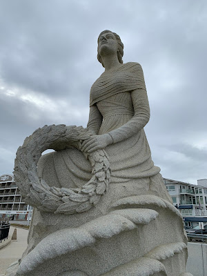
The memorial features a statue of a young lady facing seaward and holding a wreath in honor of the New Hampshire residents who served in the armed forces and were lost at sea.  Around the upper base of the memorial, two verses of poetry are inscribed in large letters:

Breathe soft, ye winds,

Ye waves in silence rest.[1]


Beneath this, on the lower base of the monument, is further inscribed:

In memory of New Hampshire’s heroic war dead

Lost at sea in defense of our country.

Following this and occupying a large part of the lower base is an alphabetical list of approximately 240 names of servicemen, with their branches of the service indicated.   The vast majority were Navy men.  Several were Marines or Coast Guardsmen.  A few were Army or Air Force.

Seeing and studying the New Hampshire Marine Memorial for the first time was a moving experience for me.  I had not expected to discover this during a leisurely and carefree day at the oceanfront.  But there it was, and it commanded my attention.  While I naturally regretted the loss of life that it represented, I was pleased that these seamen were remembered and that their sacrifices were publicly acknowledged.  I also wondered how many beachgoers on a hot summer day paused to look at this monument and contemplate its significance.

My only reservation was that the list of names did not include the many merchant seamen who perished at sea in wartime.  In the 1940s, the Merchant Marine was incorporated into a federal organization titled the United States Maritime Service, or USMS.  The seamen who manned the cargo ships, oil tankers, and troop transports suffered a casualty rate exceeded, on a percentage basis, only by the Marine Corps.   While monuments to their sacrifices do exist, they tend to be not very well known by the general public.

Nonetheless, I was pleased to come upon this monument to our state’s military personnel who tragically lost their lives at sea.  It left me with little to say but much to consider.  Fortunately, it was an uncrowded, off-season day at the beach, which created an atmosphere suitable for quiet contemplation.  I appreciated that very much.

Now, I’m pleased to share some photographs.  First, we see the full monument.  The young lady portrayed, flanked by the New Hampshire state flag, faces east toward the sea.  The building in the rear is a hotel:


Next, we have three close-up views of the young lady.  The facial expression, combined with the background of dark cumulus clouds, seems to convey a sense of foreboding: 


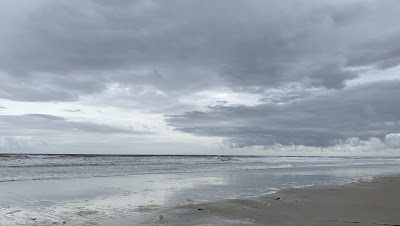
Finally, we look southeastward over the surf and beyond to the horizon of the great Atlantic Ocean.  Despite the ominous appearance of the low-hanging cloud cover, it really was a magnificent day at the waterfront:


[1] Lines from John Gay (1685-1732), “Epistle to a Lady,” 1714.  Information from https://www.seacoastnh.com/places-%26-events/nh-history/hampton-beach/sculpture-by-the-sea.


Sunday, September 1, 2024

The Celestial Refuge

When I’m unable to hurry away to the oceanfront and stare at the sea, I stay home and focus on the sky instead.  The two actually complement each other very well.  They interact with one another constantly, separating the day from the night, ordering the seasons, generating the tides, and producing both the day-to-day weather and the long-term climatic conditions.  The natural sciences of oceanography, meteorology, and astronomy are thus intimately intertwined, and we all live with the results.  I find the ways in which the elements work together a fascinating aspect of the miracle of Creation.  It would be wonderful to spend a lifetime studying these sciences of Nature.  Oftentimes, though, I’m content to simply enjoy the view and imbibe the beauty of the sky even without seeing the ocean beneath it, and I can do this without leaving my own neighborhood.

After many years of waking up for work in the middle of the night, it has become automatic for me.  Thus, from my front porch in the winter, I can admire the constellation Orion in the southeast and remember using its premier stars, Rigel and Betelgeuse, for navigation many years ago.  Beneath Orion shines Sirius, the brightest of the stars.  From the back of my house, I can see Polaris, my favorite star, and the constellations Ursa Major and Ursa Minor.  These stars don’t photograph well, though, so instead I present two pictures of the Moon.

One of my favorite celestial bodies, the Moon, when full or nearly so, served me well at sea by illuminating the horizon so I could take star sights.  I really appreciated the Moon, and when I see it now it reminds me of happy times aboard ship.  The Moon also inspires and edifies me as it fulfills its unique role in the heavens and casts its benevolent influence upon the Earth.  In this first photograph, we see a full Moon shining through a thin cloud layer in the southwest at 4:38am on Monday, July 22, 2024:


Next, we see a waxing gibbous Moon, also in the southwest, shining through a clear black sky at 8:37pm on Wednesday, August 13, 2024:

After the darkness comes dawn.  Looking east from my front porch, we see the trees silhouetted in the morning twilight at 5:16am on Sunday, August 11, 2024:

After the dawn comes sunrise.  Looking east from the neighborhood ice cream stand, we see the Sun shining through some haze as it clears the treetops at 6:11am on Sunday, July 28, 2024:


Sometimes I make the hike along the railroad track to the boat ramp on the Merrimack River and watch the day break there.  This is perhaps my favorite location in the neighborhood.  Its isolation makes it an unpopulated and quiet vantage point in the early hours, well worth the half-hour of walking needed to reach it.  In this series of photographs, we witness the dawn of a new day at ten-minute intervals from 4:30am to 5:00am on Sunday, July 21, 2024:


Then the Sun rises over the Merrimack and peeks through the trees on the eastern bank at 6:12am on Sunday, August 11, 2024:

While the Sun always rises, it is sometimes obscured by fog, a function of relative humidity, dew point, and a decreasing air temperature.  While obviously dangerous for navigation, fog often has an almost other-worldly beauty that lends a certain mystique to its surroundings.  Such is the case here on the Merrimack River at 6:35am on Sunday, October 1, 2023:


Closely related to fog is an overcast sky; both consist of water vapor at the saturation level often with certain undesirable consequences for the transportation industry.  Nonetheless, an overcast sky and the precipitation that it produces are critical components of the worldwide water cycle which is essential for the existence of all life.  I find a particular beauty in an overcast sky, especially this one over the neighborhood playground in the early morning of Sunday, August 4, 2024:

Much more popular, however, is the classical fair weather blue sky with billowing altocumulus clouds such as these in the afternoon of Sunday, August 11, 2024:

Altocumulus clouds come in a variety of sizes and shapes, all of them quite lovely, as this view from Thursday afternoon, July 18, 2024, demonstrates:

Sometimes, when illuminated from below by the Sun before it has risen above the level of the trees, altocumulus clouds can almost look like fireworks, as they do here at 5:30am on Sunday, July 7, 2024:

Then there are the colors of twilight.  In the right atmospheric conditions, the sky can seem kaleidoscopic in the early dawn.  These two eastward views from the playground at 4:56am on Wednesday, June 26, 2024, illustrate the celestial grandeur of my favorite time of day:


Finally, we see a brilliant explosion of light in the east from my front porch at 6:04am on Tuesday, August 20, 2024:

As much as I treasure time spent at the oceanfront, and as much as I consider the sea to be a refuge from the sound and fury of our secular society, I also deeply appreciate the easy access to the celestial realm that I have in my own neighborhood.  I need not go far to gaze into the heavens and find there a place of peace and quiet, a place of inspiration and edification, a place to witness the supernal splendor of Creation, and a place to find God “moving in his majesty and power” (D&C 88:47).

Monday, August 26, 2024

The Oceanfront Refuge

Although I live inland, the sea is not far away.  It’s close enough for a day’s outing and is more-or-less on the way to my mother-in-law’s house.  Sand beaches, rocky outcroppings, small seaports, and lighthouses abound along the New England coast, and visiting them never grows old.  For many years now, we’ve made it our practice to stop at some coastal point on the way to or from visiting Miss Patty’s family.  The children developed several favorite spots, and all of us enjoyed these waterfront sojourns tremendously, often wanting to stay longer than our time allowed.  Because these seaside visits were neither long enough nor frequent enough, they have become a case of absence making the heart grow fonder.  Sometimes I yearn to just look at the ocean again, somewhat like wanting to visit an old friend or a close relative.

I’ve long thought it would be nice to live in a house set on a cliff overlooking the Atlantic.  I could see the ocean every day then.  Realistically, though, this arrangement would probably not always be practical.  In lieu of it, I content myself with day trips and vacations and the taking of photographs.  Seascapes have long been one of my favorite art forms, and they are frequently the next best thing to actually being there.  Accordingly, then, I’ve selected a batch of recent seaside photographs to share here.

On Thursday, July 28, 2022, Miss Patty and I stopped at Fort McClary in Kittery, Maine, on the way home from her mother’s house.  In this peaceful and pristine park that sits well off the beaten tourist path, we rested for a while and enjoyed the magnificent view of the entrance to Portsmouth Harbor.  In this photograph, Whaleback Light stands on the left in Maine; on the right is the better known Portsmouth Harbor Light in New Hampshire.  Beyond the two lighthouses lies the open Atlantic.  On the extreme right, Fort Constitution guards the channel.  Prior to the American Revolution, this facility bore the name Castle William and Mary in honor of England’s famous dual monarchs of the 1600s:


On our last voyage from New England to New York, made on Wednesday, October 5, 2022, I took this photograph of the fabled Plum Gut Light from the ferry Cape Henlopen.  Everyone in our family has sailed past this lighthouse near the North Fork of Long Island many times.  On this particular occasion, however, the colors of the land, sea, and sky combined to form a unique canvass that made this my favorite of all lighthouse photographs:


On Monday, October 9, 2023, we travelled to York, Maine, for a lunchtime rendezvous with my mother-in-law.  While the food was good, I was much more interested in the adjacent oceanfront.  A prominent feature of this oceanfront is the famous Nubble Light, situated on a small island across a narrow channel from Cape Neddick.  One of the most iconic of American lighthouses, it attracts legions of sightseers and photographers all year round.  Endowed by Nature with magnificent beauty, it is truly a sight to behold and by which to be inspired and edified.  In this photograph, we see Nubble Light surrounded by the elements of earth, sea, and sky, manifestations of the natural sciences of marine geology, oceanography, and meteorology, all fascinating fields of study and all included in varying degrees on the Merchant Marine license exams:


Just to the right of the Nubble, we see the open Atlantic.  If we zoom in with our trusty cell phone camera, we can discern Boon Island and its lighthouse on the horizon several miles offshore.  Often invisible from the mainland because of clouds or fog, the Boon Island Light has long been and still remains an important aid to navigation.  It is always a special treat to see this great sentinel of the sea on a sunny day with a clear atmosphere:


To the left of the Nubble lies Short Sands, one of Maine’s few bathing beaches.  The water here is quite cold, so wading and not actual bathing is more the norm.  Those who do go bathing or surfing usually dress in heavy wetsuits for protection from the cold.  One need not get wet to enjoy Short Sands, though.  I was quite content to remain on the beach and simply watch the waves:


Returning to Cape Neddick after several months on Wednesday, July 17, 2024, I was again delighted to simply stare at the ocean.  Here is a lovely calm stretch of the open Atlantic, much as I saw it many times as a young mate on the bridge wing of a cargo ship:


Two weeks earlier, on Wednesday the Fourth of July, we passed through Rye, New Hampshire, and stopped to take in this view from a rocky beach.  My granddaughter, Miss Lydia, was fascinated by the rocks and the water, and she asked many questions about both.  We would have been happy to remain there all afternoon but faced with the daunting task of wending our way home through a nightmare of holiday traffic, we reluctantly returned to the car and got underway.


Visiting Portland, Maine, on Thursday, August 1, 2024, with my son Steven, I could not resist examining the cruise ship Silver Shadow and the schooner Timber Wind, both docked downtown.  The weather that day was hot and humid, and this caused an impressive buildup of cumulus clouds that hovered over the ship:


At a nearby pier lay this unidentified cruise vessel.  Not even Steven, with his young and healthy eyes, could read her name.  More noteworthy, I thought, was this additional pileup of cumulus and borderline cumulonimbus clouds.  Not surprisingly, it rained later that afternoon.


Finally, we see the diminutive Spring Point Light at the end of the breakwater in South Portland in an unusual view from across the harbor.  When my children were young, this site served us well as the setting for several picnic lunches.  At the end of the long jetty, we had a magnificent view of Portland Harbor and Casco Bay, and we watched as a parade of oil tankers, cruise ships, pilot boats, and ferries passed in front of us.  On this more recent visit, there was little traffic on the water, but the view, even on a cloudy and hazy day, was still fantastic.  Once again, I would have gladly stayed there all afternoon, but duty called, and I had to go.


The duties of life have called me away from my waterfront “happy place” many times.  While it was always sad to leave the sea and attend to business, I’ve always been grateful to have visited the seaside, even if only briefly, and to have been uplifted and edified by it.  The oceanfront has long served me as a refuge from the commotion and contention of life.  It is a place of peace and serenity, a place to enjoy the primordial beauty of Creation, a place to seek and experience Divinity, and a place to “be still and know that I am God” (D&C 101:16). 

Sunday, July 21, 2024

Transiting the Canal

The Mercury arrived at the Pacific entrance to the Panama Canal at 5:00am on Wednesday, June 25, 1980.  En route from San Diego, California, to Wilmington, North Carolina, she was fully loaded with a high-priority cargo for the U.S. Marine Corps, part of the American military response to the Iranian hostage crisis.  This cargo gave the Mercury precedence over several other cargo ships that lay at anchor waiting their turns to transit the canal.  Gliding easily through the placid water off the south coast of Panama, she slowed to take on pilots and linehandlers, and then proceeded into the canal entrance, past the port of Balboa, and under the large center span of the Bridge of the Americas.  Just ahead stood the Miraflores Locks.

This was the first of my two experiences with the Panama Canal.  I was very young and had a third mate’s license that was just over a year old.  Everything in Panama was brand new to me, and I found it all fascinating.  As the Mercury entered the Miraflores Locks, she was guided forward and into position by railroad locomotives called “mules” on the dock.  These were connected to both sides of the ship by heavy steel hawsers.  Then the lock gates were closed, valves were opened, and water gravitated into the chamber from the next and higher chamber just ahead of it.  Then the lock gates between the two chambers were opened, and the ship was eased forward into the second chamber.  This one was filled from Miraflores Lake, which lay between the Miraflores and Pedro Miguel Locks.  All this was orchestrated in a small Spanish mission style building adjacent to the locks.  After exiting the Miraflores Locks, the Mercury sailed the short distance across this intermediate lake to the Pedro Miguel Locks, and the process was repeated.  Here, though, there was only one step, that is, the ship passed through only one lock chamber, in order to reach the uppermost water level.

From the Pedro Miguel Locks, the Mercury transited the famous Culebra Cut through the backbone of the Latin American mountain chain.  Later renamed Gaillard Cut for the engineer who headed this feat of construction, it was a most impressive but also incongruous sight with jagged walls of rock towering along both sides of the ship.  After eight miles of this, the ship entered Gatun Lake, which stretched 23 miles across the center of the isthmus to the north.  Following a series of twisting and turning channels around islands and through the jungle, the Mercury at last arrived at the Gatun Locks.  Here the ship passed through three lock chambers in fairly quick succession and was lowered back down to sea level.  Seven miles later, she exited the canal at Limon Bay, next to the port of Cristobal.  After discharging the pilots, the vessel proceeded into the open Caribbean.  It was by now mid-afternoon; the transit had taken close to ten hours.  With Panama fading from sight, the Mercury increased speed and headed northeast into a strong wind and building waves.

Possibly unique among the world’s waterways, the Panama Canal was certainly distinctive in a manner that commanded my attention and has held my interest ever since.  On a shipmate’s recommendation, I later read David McCullough’s great book[1] about the canal’s construction, a tale replete with engineering, history, political intrigue, medical advances, and tragedy.  While the Panama Canal has been long and rightly recognized as one of the great man-made wonders of the world, it is sobering to consider the horrific price in human life that its construction cost.  We who benefit from the canal today owe an immense debt of gratitude to those who lost their lives building it.  Such thoughts came to me later in life, though.  When I was young, it just felt exciting to have even a very small part in something so famous.

My second experience with the Panama Canal took place a few years later aboard the Comet.  En route from New Orleans, Louisiana, to San Lorenzo, Honduras, she arrived off Cristobal and anchored there at 6:00pm on Monday, January 30, 1984.  The ship rested easily at anchor in very calm water, no wind, and stifling heat overnight.  Soon after breakfast on Tuesday the 31st, a pilot came aboard, and the Comet weighed anchor and proceeded into the canal.  This transit was in the opposite direction of the Mercury’s, but was otherwise quite similar.

The pilot on this transit was an exceptionally friendly fellow.  I remember when the Comet passed from Gatun Lake into Culebra Cut he remarked to us, “Well, this is the part that God did not intend to be a canal.”  And he chatted with us about the difficulties of dynamiting a waterway out of a mountain range.  He also gave us tourist brochures complete with photographs and text that described the canal and its history and operations.  I still have this bit of memorabilia, which I found very informative.

At 5:00pm that day, after completing her transit of the canal, the Comet moored in Balboa for cargo operations.  I went ashore briefly and walked around the waterfront.  At the entrance to the docks, a taxi driver spoke to me in badly broken and heavily accented English.  He offered to bring me into downtown Balboa for “only $30.00.”  When I politely declined, he exploded angrily and cursed me out in very loud, completely fluent, unbroken, and unaccented English.  I found this performance rather amusing.

That evening, actually at 12:30am on Wednesday, February 1, the Comet sailed from Balboa.  Another pilot took her under the Bridge of the Americas and out to sea.  After he departed, the ship set a course for the coastwise run to Honduras, and I left the Panama Canal behind for the last time.

In the forty years since, many changes have come to the Panama Canal.  Foremost among these is the transfer to Panamanian ownership.  The erstwhile American colony called the Canal Zone has passed into history.  Equally important are the new and bigger locks, built to accommodate today’s gargantuan container ships and oil tankers.  The original locks, 1,000 feet long and 110 feet wide, were by the standards of their time enormous.  They are still used, of course, but supplemented by the newer and larger ones.  Additionally, two more bridges now cross the canal; the cargo ports of Cristobal, Colon, and Balboa have expanded; and webcams now monitor all traffic passing through the locks.  So I can watch all the action on a computer screen at home!

For many years I was the only member of my family that had gone to Panama.  This changed on Friday, January 8, 2010, when my son James entered the canal from the north aboard the cruise ship Zuiderdam of the Holland America Line.  This vessel transited the Gatun Locks and entered Gatun Lake, where James disembarked and then completed his transit from Gamboa aboard the ferry Tuira II.  From Balboa, he recrossed the isthmus by bus and rejoined the Zuiderdam at the Colon Cruise Terminal.

Next, my son Michael, while on a hitchhiking odyssey through Latin America, visited the Miraflores Locks, witnessed the passage of a ship through them, and then toured the adjacent Miraflores Visitor’s Center on Wednesday, December 7, 2016.

Then, Miss Patty saw the Panama Canal from an airplane on Tuesday, May 21, 2019.  She was traveling on Avianca Airlines to Brazil to assist with our newborn grandson David, and she changed aircraft in Panama City.  When she returned on Saturday, July 6, the view of the canal was unfortunately obscured by clouds and rain.

Little did I think in the 1980s that the Panama Canal would later become such a family affair!  I never imagined then that one son would sail on cruise ships, that another son would hitchhike from Pennsylvania to Panama, or that I would have family in Brazil.  Life is indeed full of surprises.  Through these surprises, though, the Panama Canal has served four of us well as a common interest and as a waypoint in our travels.  Time will tell if the rest of the family will also go to Panama.

In the preface to his great book, David McCullough pays tribute to the Panama Canal, describing its construction as

a profoundly important historic event and a sweeping human drama not unlike that of war.  Apart from wars, it represented the largest, most costly single effort ever mounted anywhere on earth…. It affected the lives of tens of thousands of people at every level of society and of virtually every race and nationality.[2]

Since its construction, the Panama Canal has affected the lives of hundreds of millions of people, including my own, as one of the world’s most vital transportation links.  More freight passes through Panama than most folks can imagine, and there is no end of it in sight.  Without Panama, the global supply chains and the world’s economies would be largely crippled. 

Finally, there remains in the annals of Panama Canal literature an additional, if tenuous, family connection.  My grandparents never travelled to Panama, but they owned an edition of the Encyclopaedia Britannica which contains an article[3] on the Panama Canal co-authored by Colonel George W. Goethals, one of the chief engineers of its construction.  This prose, now in my possession, symbolically links the family, the sea, and the Panama Canal, and prompts me to recall many golden opportunities and happy memories!

Now, we have some photographs to consider: 


Two views of the anchorage taken from the Comet in Limon Bay off Cristobal near the north end of the Panama Canal on Monday, January 30, 1984.  I took more pictures than these, but my camera was malfunctioning, which I did not realize until later, and so only these two survived. 

The following photographs come from the tourist brochure which the friendly pilot aboard the Comet gave me.  I don't remember his name, but I remain very grateful to him for this gift.

In this first picture, we have an aerial view, looking north, of the Miraflores Locks and Lake Miraflores.  In the upper left corner, we can see part of the Pedro Miguel Locks.  

Next, we look the other way and see the canal's southern terminus, and beyond that, the Pacific Ocean.  In the center stands the Bridge of the Americas, a structure that dates from 1962.  On the left lies part of the port of Balboa.

Here, near the northern terminus of the canal, we see Limon Bay with its extensive anchorage and the finger piers of Cristobal.  The city proper of Colon lies to the right, just out of the picture.

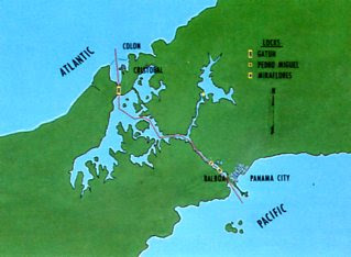
This rudimentary map shows the basic layout of the canal, most notably its northwest to southeast layout, something that surprises many people.

Finally, this schematic profile, while not drawn to scale, illustrates the canal's elevated course through the mountainous terrain of the Panamanian isthmus.  A short but unlikely route for a ship!


[1] David McCullough, The Path Between the Seas: The Creation of the Panama Canal 1870-1914, New York: Simon & Schuster, Inc., 1977.  A truly outstanding book by one of my favorite authors.

[2] Op. cit., p. 11.

[3] George W. Goethals and Clarence S. Ridley, “Panama Canal,” in Encyclopaedia Britannica, London: The Encyclopaedia   Britannica Company, Ltd., 1941, v. 17, p. 171-177.   In 1941 Mr. Ridley was the governor of the Panama Canal Zone.